Content
Published:
This is an archived release.
One third of urban settlements used for residential purposes
The share of build-up area, defined as buildings, near-building areas and areas covered by roads, constitutes between the half and two thirds of the land-use in urban settlements. The greater urban areas had less construction activity in 1999 compared with settlements with less than 20 000 inhabitants.
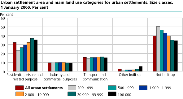
Preliminary calculations reveals that the area used for small dwelling houses and related ground, in average covered 32 per cent of the total area in urban settlements. The share varies from 23 per cent of the total area in urban settlements with less than 500 residents, to 37 per cent of the total area in urban settlements with between 20 000 and 100 000 residents. About 10 per cent of the total area in urban settlements is used for business purposes, and just above 15 per cent for roads and transport. This seems to be independent of the size of the settlements. The minor urban settlements have about 50 per cent unclassified land, while the biggest urban settlements have 35 per cent unclassified.
On average the use of land for small dwelling houses (detached and undetached houses), near-building areas included, covers about 25 per cent of the total area in the urban settlements. The share increases from 17.5 per cent of the total area in urban settlements with less than 500 residents, to almost 29 per cent of the total area in urban settlements with between 20 000 and 100 000 residents. For the cities of Oslo, Bergen, Stavanger/Sandnes and Trondheim (incl. these cities are share of urban areas in adjacent municipalities) the area for small dwelling houses occupied 23.5 per cent of the total area. However, the element of land used for building blocs for dwelling purposes in these four largest Norwegian cities constituted a total of 6 per cent of the urban area. This is approximately 3 times as much as the average for all urban settlements.
One tenth of the urban settlement area were used for industry and trade
Land used for industry, trade and services constituted a total of near 10 per cent of the urban settlement area, with a vague tendency to a larger share of industrial areas in the smallest urban settlements. The preliminary calculations indicate that built-up and related land was evenly distributed on different land use purposes, almost independent of the size of urban settlement. However, that is with an exception for build-up land used for agriculture and related primary industry, where significantly larger shares of land were found in the smallest urban settlements. A possible explanation on why many buildings for agricultural purposes were located inside urban settlements is that these farm buildings have been included in the expanding urban areas over time, but that the building register is not updated concerning the change of main use of building.
Highest building activity in medium large urban settlements
77 per cent of the population resided in urban settlements by the 1 January 2000, nevertheless only 54 per cent of all reported new constructed or expanded buildings in 1999 were located inside these urban settlements. 63 percent of new constructed or expanded small dwelling houses and 85 per cent of all building blocs were located within settlements
Highest activity concerning new constructions or expansion of dwelling houses was found in urban settlements with between 2 000 and 19 999 residents. In this size group of settlement, a total of 6 300 dwelling houses were constructed or expanded. Calculated as relative figures, the highest building activity was registered in urban settlements with between 1 000 and 1 999 residents.
During 1999, 262 new constructions or expansion of blocs of flats in the urban settlements were registered, whereof 97 where in the four major cities. New blocs of flats summed up to 1.2 per cent of all blocs of flats in the urban settlements, while new small dwelling houses summed up to 1.1 per cent.
Term build-up and related land, calculation of land use areas, data sources and uncertainty
Build-up and related land is the area of the buildings footprint and the buildings adjacent influence area the site/parcel. The parcel area, and use of this land is calculated on the basis of data about the building and property in the GAB register and the road register.
The figures are associated with some uncertainty. The uncertainty in the register-based land use figures are first and foremost due to varying quality of the building and property information in the GAB. Statistics Norway is now working to improve the current data sources and expand the data basis of the statistics.
Tables:
- Table 1 Urban settlement area and main land use categories for urban settlements. Size classes. 1st January 2000. Per cent
- Table 2 Land used for dwelling- and leisure buildings and garages/outhouses. Size classes. 1st of January 2000. Per cent
- Table 3 Land use for industry and commercial purposes. Size classes. 1st of January 2000. Per cent
- Table 4 Number of buildings for residential- and leisure purposes and related garages/outhouses. Size classes. Status 2000. Changes 1999-2000
Contact
-
Margrete Steinnes
E-mail: margrete.steinnes@ssb.no
tel.: (+47) 95 73 55 54
-
Svein Johan Reid
E-mail: sjr@ssb.no
tel.: (+47) 41 51 29 66

